Northumberland, England
by UK Travel Guides
Free ebook download: Northumberland, England by UK Travel Guides, legally licensed and available in PDF format.
Stretching from the edge of the Cheviots to the east coast, and from Berwick-upon-Tweed in the north to the River Blyth in the south, east Northumberland is an area of quiet villages and small market towns, majestic castles and what many people consider to be the finest coastline in England.
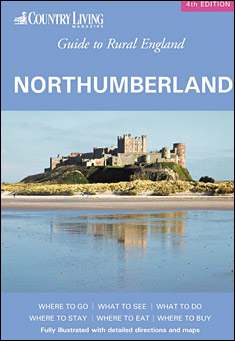
Stretching from the edge of the Cheviots to the east coast, and from Berwick-upon-Tweed in the north to the River Blyth in the south, east Northumberland is an area of quiet villages and small market towns, majestic castles and what many people consider to be the finest coastline in England. Designated as the North Northumberland Heritage Coast, the area boasts a wealth of historical attractions such as Bamburgh Castle, Lindisfarne and the Farne Islands.
For all its beauty, it’s a quiet coastline, and you can walk for miles along the dunes and beaches without meeting another soul. No deck chairs or noisy ice cream vans here – just a quietness broken occasionally by the screeching of gulls. Coquet Island is a renowned bird sanctuary where the visitor can see puffins, roseate terns, razorbills, cormorants and eiders.
Lindisfarne, a small island lying between Bamburgh and Berwick, is perhaps the most evocative place of all on the coast. It was to here that St Aidan and a small community of Irish monks came from Iona in AD635 to found a monastery from which missionaries set out to convert northern England to Christianity.
The region has withstood a tempestuous past and has been the focus of fierce fighting, nowhere more so than the border town of Berwick, whose strategic location made it a prime target in the endless skirmishes between the English and the Scots. The Border Reivers, or mosstroopers, rustled, pillaged and fought among themselves, incurring the wrath of both English and Scottish kings. All along the coastline can be seen superb castles such as those of Norham, Etal, Chillingham and Edlingham. Some have been converted into grand mansions for the great families of the area, while others are now no more than ruins.
Inland from the coast the land is heavily farmed, and there is a pleasant landscape of fields, woodland, country lanes and farms. The villages, with their ancient parish churches and village greens, are especially fine. When the Scots constantly harried this area the village green was essential as it was here the villagers guarded their cattle after bringing them in from the surrounding land.
The area to the south east around Ashington was once coalmining country, though the scars are gradually being swept away. The industry is remembered in a museum of mining at Woodhorn. Even here, however, an earlier history is evident, as the former Woodhorn church is one of the most interesting in Northumberland.
Legacies of the past can be explored at Segedunum Roman fort, Wallsend - so called because this was where Hadrian’s Wall ended. It is now the beginning - or end - of the Hadrian’s Wall Path National Trail.
West Northumberland, where the North Pennines blend into the Cheviots, is an exhilarating mixture of bleak grandeur, beauty and history. Stretching north towards the Scottish border, are the 398 square miles of the Northumbrian National Park and the Kielder Forest Park. The forest covers 200 square miles and contains Europe’s largest man-made lake, Kielder Water, opened by the Queen in 1982. To the south is Hadrian’s Wall, that monumental feat of Roman civil engineering built on the orders of Emperor Hadrian in AD122. The best known Roman monument in Britain and the best known Roman frontier in Europe, it stretches for some 70 miles from Wallsend in the east to Bowness-on-Solway in the west, and in 1987 was declared a UNESCO World Heritage Site. To see the Wall twisting across the moorland is an awe-inspiring sight, and no visitor to Northumberland should miss it. Towards the east of the area, the hills slope down towards a stretch of fertile land with little towns like Rothbury and Wooler, which in themselves deserve exploration. But up on the high ground a person could walk for miles without meeting another soul. The highest point, at 2,650 feet, is The Cheviot itself, a few miles from the Scottish border.